 The Pacific War Online Encyclopedia
|
| Previous: Negeshi Yon | Table of Contents | Next: Neiafu |
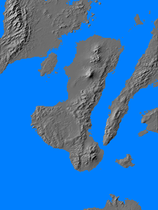
Negros is one of the Visayan Islands of the central Philippines, located
between Cebu to the east and Panay to the west. It is the fourth
largest island in the archipelago, 140 miles (225 km) long and 22 miles
(35 km) across with an area of 4903 square miles (12,699 km2).
The
southern
half of the island is mountainous
with elevations reaching beyond 4000' (1200 meters). A mountain chain
runs up the northern half of the island, reaching a maximum elevation
of 8087' (2465 meters) at Canlaon Peak, with a coastal plain to the
west. Canlaon Peak is an active volcano and the highest point in the
Visayans.
Negros was almost completely undeveloped in 1941. However, there was a good coastal road around most of the island except for the southwest coast. There were also a number of narrow-gauge rail spurs serving the numerous sugar plantations on the northwest coastal plain. Most of this sugar was exported through the port of Bacolod (122.943E 10.677N) on the northwest coast. There was an airstrip at Dumaguete (123.310E 9.310N).
The Japanese occupied the island
in late May 1942 and constructed seven airfields on the northwest
coastal plain. However, a strong Allied guerrilla force continued to hold
out in the central and southern mountains.
Allied forces returned
to the island on 29 March 1945 (VICTOR I), elements of 185 Regiment
landing unopposed on the northwest coast. They were followed by 160 Regiment.
There
were
some 12,000 Japanese troops on Negros, including three battalions from 77 Brigade in the north and a
second battalion (174 Independent
Battalion) in the south under a separate chain of command. A
third of the Japanese were unarmed service troops and ammunition
stocks were very low. However, Eichelberger later expressed the view that, had the Japanese properly deployed their troops, a counterattack could have wiped out the two battalions tht came ashore the first day.
The two American infantry regiments were joined by 503 Parachute Regiment on 7 April, coming in by landing craft after an air drop was ruled unnecessary. The paratroops assaulted the Japanese mountain stronghold where most of the defenders had retreated. This was overrun on 2 June, but a number of Japanese escaped deeper into the mountains, where they were hunted by Filipino guerrillas. Casualties were 4000 Japanese killed by 9 June and another 3350 killed by disease or guerrillas and about 250 taken prisoner. American casualties were 370 killed and 1025 wounded. About 6150 Japanese who had escaped into the mountains surrendered following the Japanese capitulation.
The southeast portion of the island was assaulted separately (VICTOR
II) by 164
Regiment on 26 April 1945. 174 Independent Battalion retreated to the hills west of Dumaguete and
repelled initial assaults, but was overrun on 28 May. Here the
casualties were 35 U.S. dead and 180 wounded and 530 Japanese dead and
15 prisoners. Another 880 surrendered at the end of the war.
References
Devlin (1979)The Pacific War Online Encyclopedia © 2010-2012 by Kent G. Budge. Index