 The Pacific War Online Encyclopedia
|
| Previous: Iron Range | Table of Contents | Next: Irving, Frederick A. |
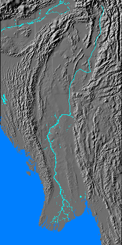
The Irrawaddy River is located almost entirely in Burma,
and most of the Burmese
population is located in
its valley and delta. The
river is heavily silted, producing a large and fertile delta some 180
miles (290 km) long and 150 miles (240 km) wide. The river is 1350
miles (2170 km) long from the confluence of theMali and N’Mai rivers to
its mouth and has a watershed of 159,720 square miles (413,674 km 2), about 61% of the area of Burma. The average discharge is 460,000 cubic feet (13,000 m3) per second, varying from 82,000 cubic feet (2,300 m3) to 1,152,000 cubic feet (32,600 m3) per second by season. This high flow makes the river a formidable military obstacle.
The river is navigable as far north as Myitkyina during the rainy
season, and navigable to Bhamo (97.231E 24.256N) year round. Ferry service was provided twice a week by the Irrawaddy Flotilla Company. Its delta is
one of the major rice-producing areas
of the world,
making Burma a major exporter of rice prior to the war.
References
Britannica.com (accessed 2012-9-15)
BurmaRiverNetwork.org (accessed 2012-9-15)
The Pacific War Online Encyclopedia © 2006-2007, 2011-2012 by Kent G. Budge. Index