 The Pacific War Online Encyclopedia
|
| Previous: Katsuriki, Japanese Survey Ship | Table of Contents | Next: Kauffman, James L. |
Kauai is the fourth largest of the Hawaiian Islands, with an area of 562 square miles (1456 km2). It is located near the western end of the main island group, 105 miles (169 km) northwest of Oahu. The eastern side of the island is relatively flat and receives abundant moisture from the northeast trade winds, giving the island its nickname of the Garden Island. The western half of the island is mountainous, reaching a maximum elevation of 5243' (1598m) at Mount Kawaikini. Nearby Mount Waialeale is sometimes cited as the wettest spot on earth, since the abrupt rise in elevation facing into the trade winds results in almost constant heavy rainfall (460 inches or 1170 cm per year.)The western massif is cut by Waimeia Canyon, a 3000' (900m) valley sometimes called the Grand Canyon of the Pacific.
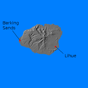
Prior to the Pacific War, Kauai was a quiet backwater, although significant sugar production was exported through the small port of Lihue (159.365E 21.979N). The only significant military facility was an airstrip at Barking Sands (159.782W 22.031N). This was built on 549 acres (409 hectares) of land
acquired by the U.S. Army in 1940. This was expanded to 2058 acres
(1534 hectares) in June 1941. The airfield saw heavy use during the
war, and B-17 bombers from the airfield participated in the Battle of Midway.
References
GlobalSecurity.org (accessed 2012-3-9)
The Pacific War Online Encyclopedia © 2012 by Kent G. Budge. Index.