 The Pacific War Online Encyclopedia
|
| Previous: Salt Lake City | Table of Contents | Next: Samar |
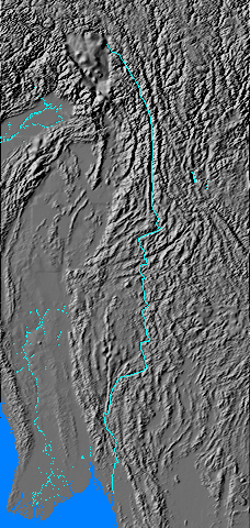
The Salween is the second river of Burma,
lying close to (and in one section defining) its eastern border with Thailand.
It arises in the Himalaya
foothills and runs some 1500 miles to
the port of Moulmein. It runs
through a deep gorge through most of its
upper reaches. The river is strongly seasonal, being wide and
swift during the
monsoon
(June to September). It had no bridges anywhere along its length in
1941, and its many rapids made it navigable only over short stretches.
Following the Japanese conquest of Burma, 56 Division was stationed along the upper Salween. The division heavily fortified the near bank of the river as a shield against any incursion of Chinese troops from Yunnan during the U-Go offensive.
References
The Pacific War Online Encyclopedia © 2006-2007, 2011, 2014 by Kent G. Budge. Index