 The Pacific War Online Encyclopedia
|
| Previous: Tavoy | Table of Contents | Next: Tayeh |
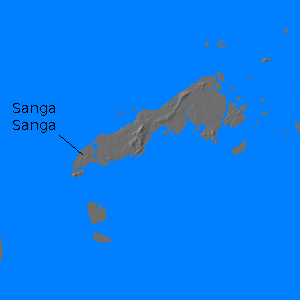
Tawi Tawi (119.886E
5.063N) is an island group with a large but exposed
anchorage at the extreme southwest
end
of the Philippines,
just off Borneo. The third largest
island in the Sulu Archipelago, it measured 10 by 30 miles (16 by 48
km) with a maximum elevation of 1800' (549 meters).
It was
devoid of facilities in 1941, but the Japanese
used it as
a fleet anchorage late in the war because of its proximity to the Borneo
oil
fields. The anchorage lacked an airfield,
and
American
submarines
were able to track the
movements of the Japanese fleet at this exposed location.
Japanese
training
exercises were correspondingly curtailed, reducing the efficiency of
their
fleet.
Sanga Sanga Island, off the southwest end of Tawi
Tawi, was occupied by a battalion
from 163
Regiment on 2 April 1945. A 6500' (1980 meter) airstrip was
completed by 2 May and used by RAAF units to
support operations in north Borneo.
References
The Pacific War Online Encyclopedia © 2007, 2009-2010 by Kent G. Budge. Index