 The Pacific War Online Encyclopedia
|
| Previous: Arnold, William H. | Table of Contents | Next: Artem Class, Russian Destroyers |
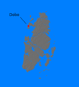
The Aroe Islands (Aru Islands) are a tightly clustered group of islands south of New Guinea and at the eastern end of the Indonesian island arc. The islands are relatively flat and are separated by deep channels. Most of the land area (about 3300 square miles or 8500 km2) is covered by swampy jungle, although this gives way to savannah on the southernmost island of Trangan, and the islands are fringed with mangrove swamps. The chief settlement and port was Dobo (134.217E 5.757S).
The native population
(about 20,000 persons in 1941) were not warlike and subsisted primarily
on sago palm, while there was a sigificant community of Japanese pearl
divers before war broke out.
The islands had some strategic potential and were occupied by the Japanese on 30 July 1942. The Allies considered, but ultimately dropped, plans to invade the islands in June 1944.
References
Dolcemascolo (1996; accessed 2012-9-10)
Kennedy (1943; accessed 2012-9-10)
Morton (1960; accessed 2012-9-10)
"Reports of General MacArthur" (1966; accessed 2012-9-10)
The Pacific War Online Encyclopedia © 2012 by Kent G. Budge. Index