 The Pacific War Online Encyclopedia
|
| Previous: New Georgia | Table of Contents | Next: New Hebrides |
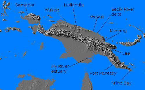
New Guinea is the second largest island in the world, 1306 miles (2101 km) long and 500 miles (805 km) wide, with an area of 304,486 square miles (788,615 km2). Geologically, the island is part of Australia. It is split down the middle by a central mountain range, which reaches to 9000 feet (2700 meters) or higher along most of its length and is nearly impassable. The highest point is Carstentz Pyramid (now known as Puncak Jaya) at 16,023' (4884 meters) in the west central portion of the island. The southeastern portion of the central range is known as the Owen Stanley Mountains, though the name was sometimes applied to the entire central range. (The proper name of the western half was the Sneeuw Gebergte or Snow Mountains.) The highest point in the Owen Stanley Mountains is Mount Victoria at 13,360' (4072 meters), located about fifteen miles (24 km) west of Kokoda. The Owen Stanleys have rich mineral resources, but only gold was sufficiently valuable for miners to brave the awful jungle environment prior to the war. Much of the coast, particularly the north coast of Papua, was very poorly charted and was surrounded by dangerous reefs, and both sides hesitated to operate warships in these restricted waters.
The climate is extremely warm and wet, with rainfalls of 150 to 300 inches (380 to 760 cm) per year. The northwest monsoon (October to April) is the wettest season while the southeast monsoon (April to September) is slightly drier and cooler. The climate is slightly less harsh in the southeast and there are other regional variations. In particular, freezing temperatures occur in the central range and the highest peaks experience significant snowfall. The island has a very high incidence of malaria, parasitic worms, and leeches, making it extremely inhospitable.The island is jungle-clad over its entire length, and in 1941 it was inhabited by perhaps 700 different tribes, most of which were still living in the Stone Age and had had virtually no contact with Westerners. The native population estimated at about a million, mostly Melanesian but with a considerably variety of physical characteristics. There were no more than 6000 Europeans settled on the island. These were mostly concentrated in the east, and there were only 204 Europeans in Dutch East Indies in the 1936 census. Much of the island was unexplored, and there were virtually no roads. Jungle tracks connected native settlements and a few airstrips built by gold miners, and the Sepik River, which flowed east into the ocean east of Wewak, was navigable for almost 300 miles (500 km). On the south coast, the Fly River is navigable for 500 miles (800 km) and much of its watershed is a vast trackless swamp. Allied and Japanese aircrew who were unlucky enough to parachute into the New Guinea jungle were rarely ever seen again. Some fell victim to headhunters, but most were simply lost in the jungle and starved.
Discovered by Antonio D'Abreu in 1512, the island was
sporadically visited but not claimed until 1828, when the Dutch claimed the western half of the
island. Germany claimed the
northeast coast in 1884 and the British promptly responded by claiming
the Papua Peninsula to the southeast. The German and British
territories were taken over by Australia
following the First World War, the German under a Class "C" League of
Nations mandate. Thus, by 1941, the
administration of New Guinea was split between the Netherlands
East Indies and Australia. The island
was, and still is,
extremely primitive, and its only significant ports in 1941 were Port Moresby
on the Australian side and Hollandia
(now Jayapura) on the
Dutch side.
The Australian half of the island was administered by
the Australia-New Guinea Administrative Unit, or ANGAU, which appears
to have been relatively enlightened in its treatment of the native
peoples, requiring the use of Motuam, the dominant native dialect, in
place of Pidgin. Though there were exceptions (such as the intensely
warlike
Orokaiva), those tribes who had had regular contact with ANGAU tended
to support the Allies,
proving particularly effective as stretcher bearers. The Australians
organized the New
Guinea Volunteer Rifles, a militia
unit of roughly battalion
strength, from among Europeans in 1939. The Papuan
Infantry Battalion was raised from among natives in 1940, and two
more native battalions were raised during the war.
All European women
and children were ordered evacuated from New Guinea on 17 December
1941, following the Japanese landings
at Sarawak. At that time, the only
organized forces under arms in New Guinea were a few hundred troops of
the NGVR at Wau and a battalion at
Port Moresby.
The war in New Guinea may be broadly divided into two
phases. The Papua campaign of 1942-1943 was waged in the Australian
half of New Guinea and was aimed at capturing or isolating Rabaul and thereby breaking the Bismarcks Barrier. The
New Guinea campaign of 1944 was aimed at advancing along the north New
Guinea coast with an eye to returning to the Philippines.
Japanese forces seized Rabaul on 23 January 1942 and rapidly transformed it into a major base. Lae was seized on 10 March 1942 against weak ground opposition. An air strike by Brown's carriers inflicted significant damage on the transport force, but did not significantly hinder the invasion. Hollandia was seized on 1 April 1942 against minimal opposition.
Japanese forces landed near Buna
on 20 July 1942 and began advancing up the Kokoda Trail towards Port
Moresby. The
defending Australians fell back as far as Imita Ridge, just north of
the port, but the Japanese advance stalled by 14 September. On 23
September the Australians counterattacked, and had pushed the Japanese
back to Buna by 19 November.
Meanwhile, the second prong of the Japanese advance on Port Moresby was halted at Milne Bay, where the Japanese landed on 25 August 1942. The Japanese were driven off by 31 August by the defending Australians, their first significant land defeat in the Pacific war.
The Americans had joined the Australians by 19 November and began an assault on Buna. This rapidly bogged down in the face of the Japanese fortifications, since the Allied troops had neither artillery nor armor support and air support was still in its infancy. It was not until 22 January 1943 that the last Japanese strong points in the area were finally mopped up.
On 28 January the Japanese counterattacked against Wau. Australian troops were airlifted
into the town and succeeded in driving the Japanese back.
Both sides now paused to regroup. The Allies finally moved against Lae in early September 1943 and cleared the town by 16 September. This was followed by a campaign to clear the Vitiaz and Dampier Straits between New Guinea and New Britain that included landings at Finschhafen, Cape Gloucester, and Saidor. This phase of the campaign ended with the fall of Madang on 24 April 1943.
The seizure of the Admiralties
in February-March 1944 and of Emirau
on 20 March 1944 by forces coming up from the Solomons isolated Rabaul,
which was left to wither on the vine.
The campaign in Papua had proven costly and slow. With Rabaul neutralized, the Joint Chiefs of Staff were inclined to shift the majority of resources towards the Navy's Central Pacific campaign, leaving MacArthur in a decidedly secondary role. MacArthur would have none of it. He persuaded the JCS to authorize a continued drive up the New Guinea coast, arguing that this would secure the left flank of Nimitz' offensive. MacArthur believed that a rapid advance up New Guinea was the only hope of keeping alive the option of an early return to the Philippines. As a result, the New Guinea campaign of 1944 was marked by audacity to the point of recklessness. But MacArthur's luck held, with a little help from excellent Allied intelligence.
MacArthur began the campaign with an unprecedented leap from Madang to Aitape and Hollandia, where landings took place on 22 April 1944. Such a long leap forward was possible because Kenney's airmen had been able to virtually annihilate Japanese air power at Wewak, which was then bypassed. MacArthur found that the terrain around Hollandia was unsuitable for large airfields, and the Japanese airfield at Wakde was seized in May 1944. The island was not large enough to base sufficient heavy bombers to support Nimitz' attack on the Marianas, so MacArthur authorized the seizure of Biak on 27 May 1944. However, the assault bogged down in the face of fierce resistance from Japanese dug into the caves overlooking the airfield, and the island was not cleared until 28 June, by which time the Battle of the Philippine Sea had already taken place.
Further landings took place at Noemfoor (2 July 1944) and at Sansapor (30 July 1944). From here, MacArthur would move to Morotai and Leyte in the Philippines.
The Japanese forces at Wewak (primarily 18 Army under Adachi) were bypassed and left
to wither on the vine. Adachi attempted to counterattack against
Aitape, but was soundly defeated at the Battle of the Driniumor River.
Thereafter his forces suffered terribly from hunger and disease,
suffering over 90% casualties by the time the war ended.
References
The Pacific War Online Encyclopedia © 2006, 2008, 2010 by Kent G. Budge. Index