The Pacific War Online Encyclopedia
|
| Previous: Cape Esperance | Table of Contents | Next: Cargo Ships (AK) |
 |
U.S. Air
Force. Via ibiblio.org |
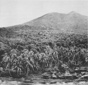
Cape Gloucester is the western tip of New Britain. The area is mostly jungle-clad, with mountains inland and swamps along the coast. However, there
are scattered areas of grassland inland on the coastal plain suitable
for airfield construction. The
area is dominated by 6600' (2011 meter) Mount Talawe. The area had a
number of native trails
but no other infrastructure. The coastline on the western side of
Borgen Bay to the east of Cape Gloucester had several breaks in the reef opening onto suitable landing beaches.
Cape Gloucester commands
Dampier Strait to its west and was occupied by the Japanese following the capture of Rabaul in January 1942. The Japanese
subsequently constructed a 3900' (1200 m) airstrip at Tuluvu, and Cape
Gloucester became an important way station for barge traffic to New Guinea.
By 1943 the Japanese garrison numbered about
10,500 troops of Matsuda Force, which was
organized from 65 Brigade, 4 Shipping Command, and elements of
17 and 51 Divisions, with 17 Division the next command
echelon.
However, Matsuda Force was scattered all
over the western tip of New Britain and on some of the islands in the
straits to the west, so that only some 7500 troops were in or near Cape
Gloucester itself. The remainder of 17
Division was at Gavuvu, on the north coast of New Britain almost
150 miles to the east.
1 Marine Division (Rupertus) landed at Cape Gloucester on 26 December 1943. The terrible terrain proved more of an enemy than the Japanese The airfield was overlooked by jungle-covered mountains and most of the shore was mangrove swamp. Aerial reconnaissance had carefully mapped the offshore reefs but failed to detect the swamp. Three separate reconnaissances by Alamo Scouts identified two small landing beaches about five miles (8 km) from the airfield that were weakly defended and could be approached through gaps in the reefs.
| CTF 76 (Barbey) |
|||||
| |
First
Echelon |
||||
| |
APD Task
Group Beach Yellow 1 |
||||
| |
APD Stringham |
||||
| APD Crosby | |||||
| APD Kilty | |||||
| APD Dent | |||||
| APD Ward | |||||
| 3/7
Marine Regiment, 720 men |
|||||
| APD Task
Group Beach Yellow 2 |
|||||
| APD Brooks |
|||||
| APD Gilmer | |||||
| APD Sands | |||||
| APD Humphreys | |||||
| APD Noa | |||||
| 1/7 Marine Regiment, 720 men | |||||
| 2 Echelon |
|||||
| LCI Task
Unit Beach Yellow 1 |
|||||
| 6 LCI |
|||||
| 2/1 Marine Regiment, 720 men | |||||
| LCI Task Unit Beach Yellow 2 | |||||
| 4 LCI | |||||
| 3/1 Marine Regiment, 720 men | |||||
| Escort
Force |
|||||
| DD Shaw |
|||||
| DD Conyngham | |||||
| DD Flusser | |||||
| DD Mahan | |||||
| DD Reid | |||||
| DD Smith | |||||
| Beach
Yellow Harbor Control Unit |
|||||
| 2 SC |
|||||
| 3 YMS |
|||||
| Cruiser
Bombardment Unit (Crutchley)
|
|||||
| Airdrome
Section |
|||||
| CA Australia |
|||||
| CA Shropshire |
|||||
| Yellow
Beach Section (Berkey) |
|||||
| CL Nashville |
|||||
| CL Phoenix | |||||
| Escort |
|||||
| Destroyer
Division 48 |
|||||
| DD Bush |
|||||
| DD Ammen | |||||
| DD Bache | |||||
| DD Mullany | |||||
| 4 other
DD |
|||||
| 3 Echelon |
|||||
| 7 LST |
Each carrying 500 troops and 150
tons bulk stores plus guns and vehicles |
||||
| DD Drayton | |||||
| DD Lamson | |||||
| DD Mugford | |||||
| DD Bagley | |||||
| 4 Echelon |
Carrying 1500 troops of
Battalion Landing Team 21, vehicles, guns, and 575 tons bulk stores. |
||||
| 14 LCM |
|||||
| 12 LCT |
|||||
| 2 rocket
DUKWs |
|||||
| 2 SC |
|||||
| 1 PC |
|||||
| 5 LCI |
|||||
| DD Reid | |||||
| DD Smith | |||||
| 5 Echelon |
|||||
| 7 LST | Each carrying 480 troops of
Combat Teams B and C and 150 tons bulks stores, vehicles, and tanks |
||||
| DD Hutchins | |||||
| DD Beale | |||||
| DD Daly | |||||
| DD Brownson | |||||
| 6 Echelon |
|||||
| 5 LST | Each carrying 240 troops of 12
Marine Defense Battalion and medical detachment, 250 tons bulk
stores, vehicles, and guns |
||||
| 3 PC | |||||
| DD Flusser | |||||
| DD Mahan | |||||
| AT Sonoma |
|||||
| 7 Echelon |
|||||
| 5 LST | Each carrying 250 Marine engineers, 250 tons bulk stores,
vehicles, and guns. |
||||
| AT Reserve |
|||||
| 3 SC | |||||
| DD Drayton | |||||
| DD Lamson | |||||
| DD Mugford | |||||
| DD Bagley | |||||
| Reserve
Group |
|||||
| LSI Westralia | |||||
| LSD Carter Hall | |||||
| AK Etamin |
|||||
| 65 Brigade (Matsuda) | |||
| Two battalions, 53 Regiment | The rest of 53 Regiment, plus 141 Regiment, were deployed too far from Cape Gloucester to affect the outcome of the campaign |
||
| Approximately 20 aircraft (at
Cape
Gloucester) |
|||
Air support was provided by AIRSOLS strikes against Rabaul, a carrier strike against Kavieng, and 5 Air Force strikes against Cape Gloucester itself. The Japanese nonetheless got enough scout planes into the air to detect the convoy, but Kusaka guessed it was headed towards the beachhead at Arawe (149.034E 6.167S), which had been established on 15 December 1943 as a diversion, and most of the Japanese air power was directed there: The diversion worked.
The preliminary bombardment at Cape Gloucester began at 0600, and
white phosphorus bombs were used
for the first time. The first wave was ashore by 0805 and immediately
began moving through the jungle. By the end of the day, some 13,000
troops and 7600 tons of supplies were ashore. The Japanese responded
with a strike at 1430 by 20 Vals
and 50 to 60 fighters. These were
detected 60 miles (100 km) out by destroyer
radar, but the four squadrons of P-38s
providing air cover missed the interception. The Japanese sank
destroyer Brownson with heavy
loss of life and badly damaged Shaw
with near misses that sprayed the hull with shrapnel. Subsequent
attacks did little damage and heavy weather
from 29 December onward put a halt to enemy air activity.
The same weather meant wretched conditions for the ground troops. However, the discovery of a small beach further west that was suitable for landing supplies relieved some of the logistical pressure. Marine engineers and 19 Naval Construction Battalion were able to construct roads and bridges to support the advance. This was fortunate as the monsoon set in on 28 December, with rain as heavy as 16 inches per day, which made the existing coastal road impassable. The Marines slogged ahead and the airfield was captured on 30 December after a sharp fight. A more difficult objective was the hills overlooking the anchorage at Borgen Bay. It took the Marines two weeks just to move into position through the jungle, and on 13 January 1944 the Marines commenced their attack on Hill 660. Tanks were unable to move up to support, but the Marines crawled up a near-vertical slope to surprise the Japanese and clear the hills on 14 January 1944. Thereafter, Japanese counterattacks against the beachhead were sporadic and ineffective. Some 3100 Japanese were killed at a cost to the Marines of 248 killed and 772 wounded. Some 25 deaths were due to falling trees in the swamps, whose roots were loosened by the heavy rain and the artillery barrage.
The terrible weather conditions proved more
memorable for many Marines than the Japanese resistance. Hot food was
impossible to prepare in the downpour, and Marines hoarded the waxed
paper and cardboard from K ration containers as a source of fuel for
heating coffee. Anything made of leather quickly developed a layer of
blue mold that had to be scraped off every day. It was impossible for
the Marines to keep their feet dry, and trench foot became a serious
problem.
Allied units would continue to probe up the island as the Japanese withdrew into their fortress of Rabaul for the remainder of the war.
MacArthur
believed the Cape Gloucester landings
were necessary to secure Dampier
Strait between New Britain and New Guinea and helped close the noose on
Rabaul. However, Morison (1950) argued that the landings were unnecessary,
since the Japanese force at Cape Gloucester had no artillery with which
to close
Dampier Strait, and Vitiaz Strait between Finschhafen and Rooke Island
was a better channel for shipping in any case. However, this was not
obvious at the time.
References
The Pacific War Online Encyclopedia © 2010-2011 by Kent G. Budge. Index