 The Pacific War Online Encyclopedia
|
| Previous: Solace, U.S. Hospital Ship | Table of Contents | Next: Solunshan |
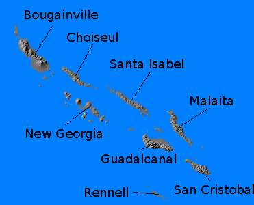
The Solomon Islands are located north of the Coral Sea and east of New Guinea. There are seven large islands in the chain, including Guadalcanal and Bougainville, as well as over nine hundred smaller islands. The chain stretches about 675 miles (1086 km) from northwest to southeast and has a total land area of about 18,600 square miles (48,200 km2). The islands are arranged in two parallel chains with New Georgia Sound, “The Slot”, a large, deep channel, between the two chains. The islands are mountainous and volcanic, and only Malaita has an exposed sedimentary basement complex. They form a fairly typical island arc, but are notable for the presence of an enormous underwater lava flow, the Ontong Java formation, just north of the chain. Earthquakes are frequent and can be devastating.
Located just south of the Equator, the islands are heavily jungle-clad, with some of the wettest terrain on earth. During November to March, the Intertropical Convergence Zone is located just to the south, and this is the wettest season of the year, with the northwest monsoon bringing temperatures above 90F (30C) and torrential rains (164 inches or 417 cm at Tulagi.) During April to October, the ITCZ shifts well to the north, and this is the closest the islands have to a dry season, with temperatures from 70F to 90F (20C to 30C). Tropical cyclones originate near the Solomons during the wet season, but usually move south before reaching full strength.
The islands were very thinly populated in 1941, with 94,700 Melanesian natives and a few hundred British and Australian administrators. Britain controlled Bougainville and Buka at the northwest end of the chain, while Australia controlled the rest. The only significant export was copra, and the Lever Brothers firm had a large number of plantations on the islands. The island of Malaita, northeast of Guadalcanal, probably had the largest population, at over 40,000. Guadalcanal itself had a population between 8,000 and 10,000. Tropical diseases, such as malaria and dengue fever, were widespread, and the native population suffered from hookworm, yaws, and leprosy. The islands and the waters around them were of so little interest to the European powers that they had never been properly surveyed.
The coasts of most of the islands lack fringing reefs, but the beaches are very narrow and sometimes backed by mangrove swamps. Many of the waterways and swamps were inhabited by crocodiles.In those areas that came under Japanese control, the natives were
given the clumsy carrot and stick treatment that so often characterized
Japanese military occupation. Extravagant promises were combined with
harsh punishment for refusing paper money, and as a consequence the Allies generally enjoyed
considerable support from the native peoples during the Solomons
campaign. The Australians were able to run an effective coast watcher network
throughout the islands.
Against all expectations, the remote and economically unimportant Solomons became the focus of the decisive campaign of the Pacific War. The Japanese had seized Tulagi during the Battle of the Coral Sea, and after the battle they began building an airfield on nearby Guadalcanal from which they planned to project power into the Coral Sea. American code breakers discovered this threat to the sea lanes to Australia, and the Americans hurriedly improvised an amphibious assault against Guadalcanal to capture the airfield. The landings took place on 7 August 1942 and marked the beginning of a brutal and costly land, air, and sea battle that lasted until 9 February 1943. By the time Guadalcanal was finally secured by the Allies, the Japanese had suffered crippling attrition, particularly of their best pilots and destroyers. The Allies had suffered heavy losses as well, but their greater resource base meant that losses could more easily be replaced.
With Guadalcanal secured, the obvious next move for the Americans was further up the Solomons chain to Rabaul. Yamamoto attempted to disrupt Allied preparations with the I-Go operation, an aerial offensive against Allied airfields and shipping. This proved counterproductive in that Japanese losses were almost as heavy as Allied losses, and the Japanese could afford them less. In particular, carrier air groups were shifted to land bases to assist with I-Go, which was a gross misuse of the highly trained carrier pilots. The Americans had also used carrier groups from Henderson Field during the crisis at Guadalcanal, but only when their carriers were put out of action, and the groups were withdrawn once their carriers were repaired.
Allied forced occupied the Russell Islands on 21
February 1943, then moved against New
Georgia (Operation TOENAILS) in
January 1943. The New Georgia campaign proved long and costly, and
thereafter the Allied commanders looked for opportunities to leapfrog
around Japanese strongholds. Their efforts to do so were made easier by
superb intelligence. Vella Lavella was seized
against light opposition in August 1943, bypassing heavily defended Kolombangara. The Treasury
Islands were seized on 27 October 1943 and Cape Torokina on 1 November
1943, bypassing the Japanese strongholds in the Shortland Islands and southern
Bougainville. Thus, by 1944, the Solomons were firmly under Allied
control and the stage was set for neutralizing Rabaul and breaking the Bismarcks Barrier.
References
The Pacific War Online Encyclopedia © 2007-2008, 2010 by Kent G. Budge. Index