 The Pacific War Online Encyclopedia
|
| Previous: Shen Fa-tsao | Table of Contents | Next: Shepherd, Lemuel Cornick, Jr. |
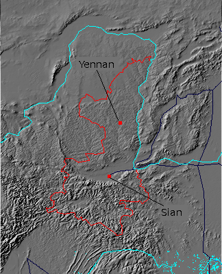
Shensi (Shaaxi) is a province of northwest China located east of the Yellow River, which forms the border with Shansi. The southern half of the province is mountainous. while the northern portion includes much of the badlands of the Loess Plateau. Between is the Wei River valley, bordered on the south by the Ch'in Ling (Qinling) Mountains and on the north by the Loess Plateau, that includes the capital of Sian, the eastern terminus of the ancient Silk Road. The Wei River valley likely formed by rifting in the Earth's crust from the collision of India with Asia that formed the Himalayas 40 million years ago. The Loess Plateau is semiarid grading to high desert in the north, which limits agriculture in in the otherwise rich soil, while the mountainous south is moister with a subtropical climate.
Resources included coal fields and oil fields, but these were just beginning to be exploited when war broke out in the Pacific.
The Japanese never penetrated this far west, but the province was split between the Kuomintang in Sian and the Chinese Communists in Yenan (109.483E 36.6N) in the north, and the military forces here were thus more interested in watching each other than the Japanese.
The Pacific War Online Encyclopedia © 2011 by Kent G. Budge. Index