 The Pacific War Online Encyclopedia
|
| Previous: Kyoto | Table of Contents | Next: Kyushu Hikoki K.K. |
Kyushu is the southernmost of the
main Japanese
home islands. It is roughly 200 miles (320 km) long and 125 miles (200
km) wide, and had a population in 1944 of 10,041,290 persons. Most of
this population was concentrated in the industrial north and northwest.
The southern portion of the island is separated from the north by
rugged mountains that restrict communications to the coasts.
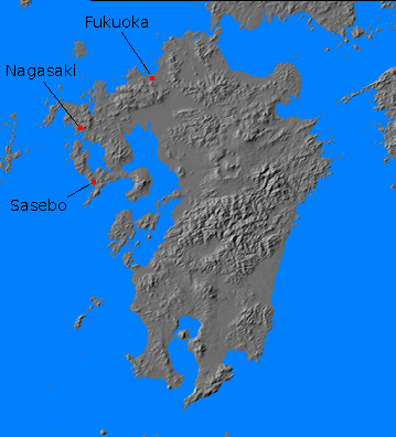
Like Honshu and Hokkaido, and other large islands in island arcs such as Java or Sumatra, Kyushu consists of a basement complex of sedimentary rocks through which volcanoes have erupted and built substantial mountain ranges. In the case of Kyushu, the basement complex contains significant coal deposits close to the surface. Production was nearly 17 million tons in 1941. Much of Japan's iron and steel industry is located in Kyushu near the coal mines, and there are major seaports at Fukuoka, Nagasaki, and Sasebo.
Within the Japanese Army, troop recruited from Kyushu had a stereotype as "fiery, impulsive men who attacked impetuously" (Edgerton 1997). Regular Army divisions drawn from Kyushu included 6 (Kumamoto) and 12 Kurume) Divisions.
Kyushu was the target of OLYMPIC, the initial
phase of DOWNFALL, the invasion of Japan.
References
Frank (1999)
Van
Royen and
Bowles (1952)
The Pacific War Online Encyclopedia © 2006, 2009, 2012 by Kent G. Budge. Index