 The Pacific War Online Encyclopedia
|
| Previous: Yano Otosaburo | Table of Contents | Next: Yasuba Yasuo |
Yap (138.076E
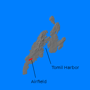
9.486N) is an island group at the northwest edge of the Carolines. Some
21 miles (34 km) long and 11 miles (18 km) wide, it is actually
regarded by geographers as four islands separated by very narrow
and shallow channels. The terrain
is somewhat rugged with a maximum elevation of 585' (178 meters)
and is densely forested. The coast is surrounded by a wide barrier
reef, though this has a number
of passes, including one into Tomil Harbor, which thus provides a
protected anchorage.
While still under German
control, Yap had become the relay point or a number of
communications cables, and this caused considerable friction
between the United States
and Japan after Japan seized
the island during the First World War. The island was further
developed under the Japanese, who for a time made it their
strongest fortress in
the Pacific islands, and it had an important airfield. A road ran
along most of the coast.
Its native
culture is most distinctive for its ancient practice of using very
large stone disks as money.
The island was struck by American carrier aircraft from Reeves' task group on 31
March 1943, during the raid on the Palaus, but damage was
relatively light. An invasion
of the island was considered, to take place simultaneously with
the invasion of the Palaus, but in the end Yap was bypassed in
favor of Ulithi.
References
The Pacific War Online Encyclopedia © 2007, 2009-2010, 2012, 2016 by Kent G. Budge. Index