 The Pacific War Online Encyclopedia
|
| Previous: Good, Howard H. | Table of Contents | Next: Goodyear Aircraft Corporation |
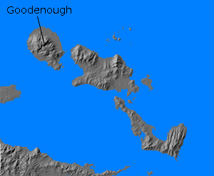
Goodenough Island (150.26E
9.37S) is the westernmost island of the D'Entrecasteaux group north
of the eastern tip of New Guinea.
Some 20 miles (32 km) long and 10 miles (16 km) wide, it is reputed to
be the most mountainous island
for its size in the world, with its peak at 8500' (2590 meters). Its
high relief is further emphasized by its significant flat coastal
plains.
A group of 353 troops from 5 Sasebo SNLF were stranded
here on 26 August 1942 when Allied
aircraft
destroyed the seven large barges
on which they were being transported after they had stopped to take a
rest. On 22 October 1942 MacArthur
assigned two destroyers to land
800 Australian
troops from 2/12 Battalion, 18 Brigade
on the southeast tip of island, who trapped the stranded Japanese
troops. Most of the surviving Japanese were evacuated by submarine on the night of 26
October, leaving a rear guard of 40 troops who were annihilated by the Allied forces.
An airstrip was
subsequently build at Vivigani (150.321E
9.306S), on the northeast coast of the island, and the island
hosted the rear echelon of 1
Marine Division during the Cape
Gloucester campaign.
References
PacificWrecks.com
(accessed 2010-8-13)
The Pacific War Online Encyclopedia © 2010, 2012 by Kent G. Budge. Index