The Pacific War Online Encyclopedia
|
| Previous: Natsushima Class, Japanese Minelayers | Table of Contents | Next: Navajo Class, U.S. Fleet Tugboats |
 |
U.S.
Army. Via ibiblio.org |
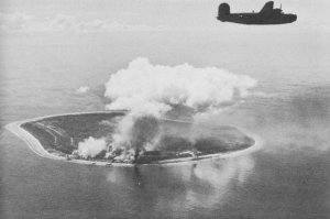
Nauru (166.925E 0.539S) was an isolated but rich phosphate mining center under Australian control in 1941. It is a small island (8.2 square miles or 13.5 km2) located 390 miles (630 km) west of the Gilberts and 155 miles (250 km) northwest of Ocean Island. Its topography consisted of a narrow coastal plain 150-300 yards (140 to 270 meters) wide backed by 100' (30 meter) cliffs rising to the central plateau, whose maximum elevation was 213' (65 meters). This made it an ideal nesting site for millions of seabirds over thousands of years, whose droppings reacted chemically with the coral cap of the island to produce phosphate rock. The island is surrounded by a narrow reef with numerous coral heads exposed at low tide.
The island experiences its heaviest rainfall in
November to February, when the Intertropical
Convergence Zone shifts over the island. During the remainder of
the year, the ITCZ shifts north and the island experiences easterly
winds and something of a dry season. Vegetation was largely restricted
to the coastal plain, as the mining operations had stripped much of the
soil from the central plateau. However, there was a more heavily
vegetated area around Buada Lagoon on the southwest of the central
plateau.
The phosphate was extensively mined, with production at 810,000 tons per year in 1941. The mining operations left the central plateau pitted and cratered, with the excavation going as deep as 50' (15 meters) in places. Because the island had no anchorage to speak of, the phosphate was loaded at artificial moorings constructed at the edge of the reef on the west side.
The island was claimed by Germany in 1888 but the value of the
phosphate was not recognized until 1900. Mining began six years later.
The Australians seized the island in 1914 and received a League of
Nations Class C mandate in 1920. The native population was about 1800 natives of mixed
Micronesian, Polynesian, and Melanesian ancestry, together with 1500
indentured Chinese laborers, 50 laborers from other Pacific islands,
and 170 Europeans. The natives retained land ownership and received
royalties for the phosphate but did not generally work the mines. There
was a coastal road clear around the island and a narrow-gauge railway
from the moorings on the west coast to the mines.
German commerce raiders sank five Australian ships
off the island on 6 December 1940. The Japanese
in turn bombed the island on 9 December 1941. The remaining Europeans
were evacuated in February 1942 and elements of 43 Guard Force occupied the island
on 25 August 1942. An airfield
was constructed on the southern coastal strip by March 1942. Following
the Makin raid, the garrison was
reinforced to a strength of about 3700 troops. About 1200 natives were
forcibly relocated to Truk, of whom a
third perished.
The Allies made plans to invade Nauru at the same time as Tarawa, but when the top commanders saw models of the island topography, the invasion was mercifully canceled and Makin was substituted.
On 4 December 1943, Lee's force of two carriers, five battleships and 12 destroyers raided the island in an attempt to catch a large force of "Bettys" that had retired here from Kwajalein. However, the American strikes were too late to find many targets. Perhaps eight Japanese aircraft were destroyed, at a cost of four American aircraft and damage to a destroyer.
At its peak, the Japanese base had two runways
protected by 200 antiaircraft
guns.
Climate Information:
Elevation 87'
Temperatures: Jan 88/74, Apr 990/75, Jul 89/74, Oct 90/74, record 95/63
Rainfall: Jan 15/12.4, Apr 6/3.7, Jul 11/6.1, Oct 5/3.9 == 75.1" per annum
References
The Pacific War Online Encyclopedia © 2007-2008, 2010 by Kent G. Budge. Index