 The Pacific War Online Encyclopedia
|
| Previous: Palau Islands | Table of Contents | Next: Palembang |
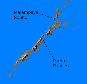
Palawan is a large island in the soutwest Philippines, some 270 miles (430 km) long and 15 to 30 miles (25 to 50 km) wide with an area of 4500 square miles (11,700 km2). It is mountainous and jungle-clad, with a central mountain chain reaching to 5850' (1783 meters). It was largely undeveloped in 1941, except for Puerto Princesa (118.74E 9.74N). The anchorage at Malampaya Sound (119.45E 10.74N) was occasionally used by U.S. seaplane tenders. There were no improved roads. Most of the population lived north of Puerto Princesa.
The island is situated to receive the full brunt
of the June to September monsoon.
This brings heavy rain to the northern and western portions of the
island. The east coast is in the rain shadow of the central mountains
and experiences a dry season.
The island was occupied by the Japanese in early 1942, who
constructed two airstrips near
Puerto Princeso. The west coast has numerous small anchorages that
provided shelter for Japanese merchant
ships making the run from Borneo
to the Philippines.
The Japanese massacred
a group of about 140 of prisoners
of war here on 14
March 1944. The
prisoners were forced into two air raid shelters and soaked with
gasoline, then lighted torches were thrown in. Those prisoners who
tried to escape the flames were shot down. Three prisoners managed to
escape and were sheltered by natives until the Allied landings.
The island was defended by just two battalions of troops in 1945, 174 Independent Battalion and 131 Airfield Battalion, a total of about 2700 troops. The airfields around Puerto Princesa were coveted by the Allies, since they would allow their air forces to extend their reach across the South China Sea. Thus, on 28 February 1945, Fechteler's Amphibian Group 8, with cover from Rigg's Cruiser Division 12, landed 186 Regimental Combat Team at Puerto Princesa (Operation VICTOR III). The lack of suitable beaches meant that the troops went in in LVTs, and there was considerable difficulty finding places for the LSMs and LSTs to unload. However, no serious resistance was encountered ashore until 2 March, when patrols encountered the Japanese strongholds in the foothills. The island was under Allied control by 10 March.
The Japanese had constructed an airstrip of poor quality concrete. This was improved and extended using Marston mat, and by April it could base 175 aircraft.
References
Marston
(2005)
Morison
(1958, 1959)
The Pacific War Online Encyclopedia © 2007-2011 by Kent G. Budge. Index